-
|
I "played" a little bit with overpass-turbo and extracted all french departments (still a draft) to display "low_emission_zones" I found a similar discussion here, dealing with BRouter NoGo areas. But finally it's not the same. The "No go" areas deal with what the name says, defined zone where the BRouter algorithm should plan a bypass. Coming to Cruiser:
Cruiser offers the possibility to import own pois and tracks. Can we have the same solution for polygon area overlays? And then to select the color and transparency? - that would be great. For a first test, I attached the data from the map above as gpx file (zipped) and as original Overpass-Turbo query content for copy/paste to reproduce request if needed. |


Beta Was this translation helpful? Give feedback.
Replies: 12 comments 58 replies
-
|
@DIrgi thanks for the suggestion. Overpass can export in GeoJSON format? Cruiser can display GeoJSON content, it's just not public yet, unless we need it. 🙂 |
Beta Was this translation helpful? Give feedback.
-
|
Yes it can export geojson but it does not work neither as track nor as route. |
Beta Was this translation helpful? Give feedback.
-
|
As mentioned, the GeoJSON format is not currently public in Cruiser. We can think how it could be used, e.g. in "My collection" requires a new implementation. For now can use GPX tracks and draw them as lines. |
Beta Was this translation helpful? Give feedback.
-
|
"My collection" makes absolutly sense. Like a track, POI or Route. Then maybe an "area" just as overlay (without any routing influence - just informal) ECO zones are coming more and more - See screenshot for Europe - Even in the OSM data they are not 100% listed. i.e. I started the tread with an example picture about french department zones. I check via JOSM but in France there are no "low emmission zone" definitions so far for whole departments (ZPAd) , just for certain city areas(ZFE). But since these emission zones affect a complete department, I asked for the department borders to receive the outcome for the low emission department zones. |

Beta Was this translation helpful? Give feedback.
-
|
An old image:
|

Beta Was this translation helpful? Give feedback.
-
|
Displaying polygon overlays is one thing. Store them like favorites / routes / tracks with adjustable properties, |
Beta Was this translation helpful? Give feedback.
-
|
Will we see GeoJSON format in Cruiser 5 ? |
Beta Was this translation helpful? Give feedback.
-
|
It will be available, we will see when, as many things are in the works all the time. 🙂 |
Beta Was this translation helpful? Give feedback.
-
|
Next Cruiser will also import GeoJSON files:
We can rename "My collection | Tracks" to "Tracks / Areas" and store 2 overlay types:
|
Beta Was this translation helpful? Give feedback.
-
...a new section called "Areas"!? |
Beta Was this translation helpful? Give feedback.
-
|
Or zones but area is on a more broader scale |
Beta Was this translation helpful? Give feedback.
-
|
It's better to not introduce a new interface just for a different type, We can always create different groups to separate the items. There are the main categories "Favorites" and "Routes" with specific uses |
Beta Was this translation helpful? Give feedback.
-
|
So why ask then when you don't want to introduce a new category at all? I even don't get why it should be "better to not introduce a new interface just for a different type"... I'm sure you will figure something out. |
Beta Was this translation helpful? Give feedback.
-
|
The question was asked 2 days ago, work has progressed a lot since then. The icon is the smallest part of the work, the implementation (and maintenance) has a much higher cost. |
Beta Was this translation helpful? Give feedback.
-
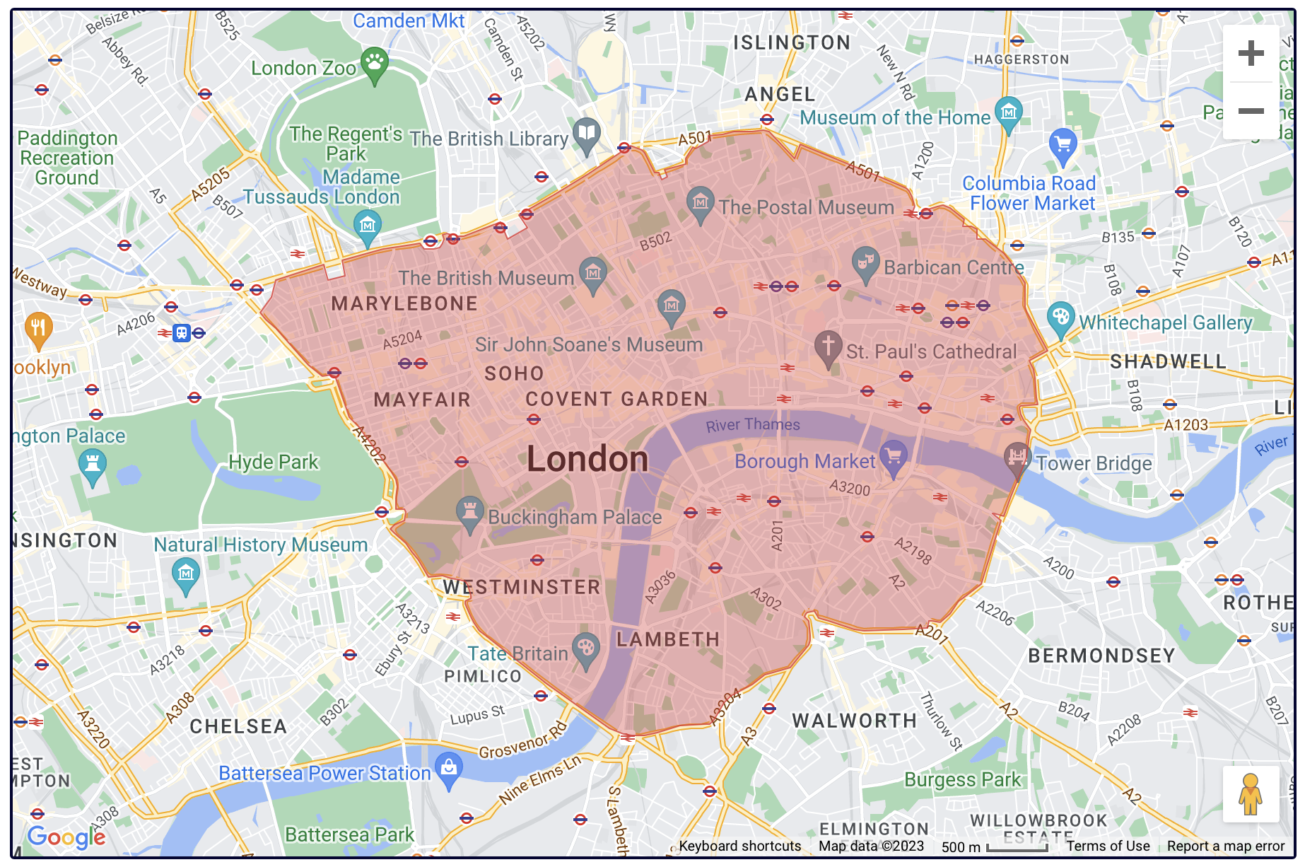
|
I have a (slightly modified) Polyfile creator (using Leaflet) here for creating custom map areas, turns out that GeoJSON is also offered so I can conjure-up all sorts of fancy areas/zones where a simple radius may not be sufficient. For starters, the London Congestion Charge Zone:
GeoJSON content: |

Beta Was this translation helpful? Give feedback.
-
|
This quickly becomes complicated. GPX are designed to host points and lines. And there is no way for the users to design or find these shapes, The best is to follow BRouter website's model and interface and use avoid circles. |
Beta Was this translation helpful? Give feedback.
-
|
About the favorite no-go areas we have this thread: |
Beta Was this translation helpful? Give feedback.
-
|
Radius areas might be easy to define but a zone is never radius based. Finally with a circle you either add areas which are then not included or vice versa, which are normally out of it |
Beta Was this translation helpful? Give feedback.
-
Q: @MotoUKRider |
Beta Was this translation helpful? Give feedback.
-
|
@0709wiwiwi I might need a new mouse! I had nothing else better to do, so made it manually using my Polyfile webpage by following the reasonably high-quality map that the Transport for London offer. |
Beta Was this translation helpful? Give feedback.
-
|
GeoJSON area overlays will be available in the next Cruiser.
|


Beta Was this translation helpful? Give feedback.
-
|
@0709wiwiwi suggested changing the "NoGo" to "nogo" in the name and that was it! Now it works OK 👍 I wasn't aware of case sensitivity. Thanks for looking into the problem 🙂 |
Beta Was this translation helpful? Give feedback.
-
|
@Ciutnik really, it wants lowecase? This is problem of Android and how it handles the external file names. |
Beta Was this translation helpful? Give feedback.
-
|
short ...I suppose (should read the documentation) that BRouter expect it this way as non Capitalised. |
Beta Was this translation helpful? Give feedback.
-
|
BRouter no-go documentation is here: https://github.com/abrensch/brouter/blob/master/docs/users/android_advanced.md#using-nogo-areas |
Beta Was this translation helpful? Give feedback.
-
This tale of doom does come back very often. |
Beta Was this translation helpful? Give feedback.
-
|
The fact that Android tightens the security restrictions from release to release is understandable on the one hand, but annoying on the other. The restrictions for external files may also become critical, but Import/Export will still have to exist. So external file handling has to be there anyway. But nevertheless to minimize the use of external files, the nogo areas in "My collection" - okay! All "My collection" items are handled globally, thus all nogo-areas would then be applied in all profiles. That's sub optimal.
I accept the objection that this idea increases the complexity of Cruiser. But the topic of nogo areas has already been placed in the "Advanced" section. And we can see what leveling down to mediocrity feels like at K3 ... |


Beta Was this translation helpful? Give feedback.
-
|
@WolfgangZ42 thanks for the detailed description. Indeed, we could improve the use of all favorite types with the profiles. I still have to think about an optimal implementation. 🙂 |
Beta Was this translation helpful? Give feedback.
-
|
Import GeoJSON points, lines, polygons in favorites is available in:
|
Beta Was this translation helpful? Give feedback.
-
|
I'll test. |
Beta Was this translation helpful? Give feedback.
-
They can as the visibility and the no-go flag are set separately. |
Beta Was this translation helpful? Give feedback.
-
|
Please do not set many and complex polygons as no-go areas. This can significantly slow down the route calculation. |
Beta Was this translation helpful? Give feedback.
-
|
Test wit New Cruiser APK: cruiser-5.0.0-b1 First of all it seems that I can import polygon areas to mark/display the french environment zones.
Question: will it be possible to have this as an hatched area on demand in all 4 directions like this: |


Beta Was this translation helpful? Give feedback.
-
|
btw if someone need to have the french crit'air zones: |
Beta Was this translation helpful? Give feedback.
-
Import them only, make them visible, but do not set them as no-go areas.
I tried to all these France polygons as no-go areas and routing became too slow. If want to use them as no-go areas, you need to import them as separate layers
Do you mean a pattern instead of the semi-transparent fill color of the polygons? |
Beta Was this translation helpful? Give feedback.
-
|
yes, "pattern" English translation named it as "hatched". Finally I'm not aware how it'll look like at the end maybe it's to strong to disturbing.... |
Beta Was this translation helpful? Give feedback.
-
|
Beta Was this translation helpful? Give feedback.
Import GeoJSON points, lines, polygons in favorites is available in #641
"Closed" GPX tracks / routes can also be imported as polygons
Polygons can be used as no-go areas in route planning